Did Juan de la Cosa Abandon Ship?
La Santa María ran aground in the first minutes of December 25, 1492, off the northern coast of Haiti. Columbus recorded that his master, Juan de la Cosa, abandoned the ship. But the account does not survive a seaman's reading — and most historians have taken Columbus at his word.
A Note on Methodology
Columbus's Own Account
La Santa María, Christopher Columbus's flagship, was lost after running aground near modern-day Cap-Haïtien, Haiti, around midnight on the night of December 24–25, 1492. Columbus claimed that Juan de la Cosa, the ship's master and owner, attempted to abandon her. That claim deserves far more scrutiny than it has received.
The only surviving account is Columbus's journal, the Diario, which survives in an abridged copy made by Bartolomé de las Casas. The passages below are translated from Alvar's transcription of that manuscript.[1] The English most often quoted — including by Wikipedia — is Markham's 1893 translation,[2] which, as the table after the passage shows, reverses the meaning of the Spanish in several places that matter.
December 23–24: The Coast Had Been Scouted
On Sunday, December 23, Columbus sent his boats to the village of the local cacique, Guacanagarí. The Diario places that village "almost three leagues S.E." of a headland Columbus called Punta Santa.[2] Markham's edition, following the Spanish editor Navarrete, identifies Punta Santa as the point "now called San Honorato" — Pointe Honorat, at the eastern side of the approach to the Baie de l'Acul.[2][6]
On December 24, before leaving the harbor Columbus called the Sea of Santo Tomé (identified as the Baie de l'Acul), he recorded sailing directions that show he knew exactly how reef-strewn this coast was:
"…a very great reef [restringa] comes from the west, and even out to sea beyond it there are some three shoals [baxas]… Another reef and shoals [restringa y baxas] come from the east to the said island of Amiga, and they are very large and run far out to sea and reach almost two leagues toward the cape…"
Note the vocabulary: when Columbus describes reefs, he uses restringa (reef) and baxas (shoals). That matters later.
December 25: The Grounding
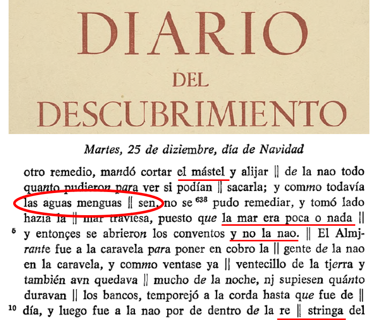
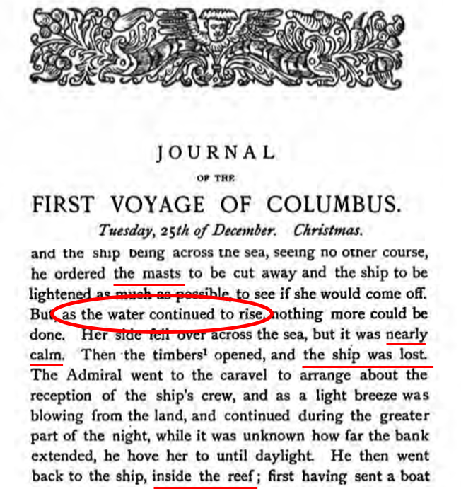
Important phrases are bolded; key Spanish words appear in brackets. The table that follows the passage shows where the widely quoted English translation departs from the Spanish.
"Sailing with little wind yesterday from the Sea of Santo Tomé to Punta Santa, off which he stood about a league until past the first watch, which would have been about eleven o'clock at night, he decided to lie down to sleep, because for two days and a night he had not slept. As it was calm, the sailor who was steering the ship decided to go to sleep and left the helm to a ship's boy [moço grumete], something the Admiral had always forbidden throughout the voyage, whether in wind or in calm.
The Admiral felt secure from banks and rocks [bancos y peñas], because on Sunday, when he sent the boats to that king, they had passed a good three and a half leagues east of the said Punta Santa, and the sailors had seen the whole coast and the shoals [baxos] that run from the said Punta Santa east-southeast a good three leagues, and they saw where one could pass — which he had not done on this whole voyage.
It pleased Our Lord that at twelve o'clock at night, since they had seen the Admiral lie down and rest, and saw that it was a dead calm [calma muerta] and the sea like water in a bowl [commo en una escudilla], all lay down to sleep, and the helm remained in the hands of that boy, and the flowing waters carried the ship onto one of those banks [bancos]. These, even though it was night [puesto que fuesse de noche], roared so that they would have been heard and seen from a good league away; and she went onto it so gently that it could scarcely be felt.
The boy, who felt the rudder [governalle] and heard the sound of the sea, cried out, at which the Admiral came out — so quickly that no one yet had felt that they were aground. Then the master of the ship, whose watch it was, came out. The Admiral told him and the others to haul in the boat they were towing astern [el batel que trayan por popa], take an anchor, and lay it out astern. He and many others jumped into the boat, and the Admiral thought they were doing what he had ordered. They cared only to flee to the caravel, which was half a league to windward [a barlovento]. The caravel would not receive them, acting rightly, and for this reason they returned to the ship; but the caravel's boat went to her first.
When the Admiral saw that they were fleeing and that it was his own people, and the waters were ebbing [menguaban] and the ship was already lying across the sea, seeing no other remedy, he ordered the mast [mástel, singular] cut, and everything they could lightened out of the ship, to see if they could get her off. And as the waters still went on ebbing [menguassen], it could not be remedied, and she heeled over, lying across the sea, although the sea was little or nothing [poca o nada]; and then the seams opened, and not the ship [se abrieron los conventos y no la nao].
The Admiral went to the caravel to put the ship's people in safety, and as a little land breeze was already blowing and much of the night still remained, and they did not know how far the banks extended, he hove to until it was day [temporejó a la corda], and then went to the ship by the inside of the reef of the bank [por de dentro de la restringa del banco]. He had first sent the boat ashore… to the king, whose town lay ahead, about a league and a half from the said bank."
Where Markham's Translation Departs from the Spanish
| Spanish (Alvar) | Meaning | Markham (1893) | Why it matters |
|---|---|---|---|
| bancos | banks, shoals | "sand-banks" | Markham decides the bottom type; the Spanish does not. |
| commo en una escudilla | like water in a bowl | "like glass" | A bowl of water implies no swell at all. |
| puesto que fuesse de noche | even though it was night | "If it had not been night" | Reversed. Columbus claims the danger was obvious even at night — an accusation, not an excuse. |
| el batel que trayan por popa | the boat they were towing astern | "the boat, which was on the poop" | The boat was already in the water. |
| a barlovento | to windward | "to leeward" | Reversed. The boat rowed upwind — the harder direction. |
| menguaban / menguassen | were ebbing | "rising" / "continued to rise" | Reversed, twice. Rising water floats a grounded ship off; ebbing water strands her. |
| mástel | mast (singular) | "masts" | Only the mainmast was cut. |
| se abrieron los conventos y no la nao | the seams opened, and not the ship | "the timbers opened, and the ship was lost" | Reversed. The hull's seams sprang; the ship itself did not break up. |
Anyone relying on the English translation is reading an account in which the tide rises instead of falls, the Niña lies downwind instead of upwind, the darkness excuses the watch instead of condemning it, and the ship breaks up instead of holding together. Each of those reversals bears directly on what happened that night.
The Conditions That Night
The Calendar
All dates on this page are in the Julian calendar, which Spain used in 1492 and which the Diario follows. December 25, 1492 (Julian) corresponds to January 3, 1493 on the modern Gregorian calendar. Any moon or tide calculation that enters "December 25, 1492" into a modern tool without converting the calendar will be nine days off. The astronomical sources below use the Julian calendar for dates before 1582.
The Moon
The phases of the moon for December 1492, from NASA's Six Millennium Catalog of Phases of the Moon:[3]
| Phase | Date (Julian) | Time (UT) |
|---|---|---|
| Full moon | December 4, 1492 | 02:19 |
| Last quarter | December 12, 1492 | 04:06 |
| New moon | December 19, 1492 | 14:44 |
| First quarter | December 26, 1492 | 06:46 |
| Full moon | January 2, 1493 | 19:25 |
The grounding came about 26 hours before first quarter — a neap-tide period, when the difference between high and low water is smallest. The moon's movements over Cap-Haïtien that day, from NASA/JPL's Horizons ephemeris system:[4]
| Event | UT | Local solar time | Note |
|---|---|---|---|
| Moonrise, Dec 24 | 15:24 | 10:35 a.m. | Rose in daylight |
| Transit (due south), Dec 24 | 21:35 | 4:46 p.m. | 70.7° above the southern horizon |
| Moonset, Dec 24 | 03:51 (Dec 25) | 11:02 p.m. | About an hour before the grounding |
| At local midnight | 04:49 (Dec 25) | 12:00 a.m. | Below the horizon; 37.2% illuminated |
Local solar time at Cap-Haïtien is UT minus 4 hours 49 minutes. The moon, a 37%-lit crescent, set at about 11:02 p.m. — almost exactly when Columbus says he lay down, "past the first watch, about eleven o'clock." When the ship grounded at midnight, there was no moon in the sky.
Wind and Sea
The Diario describes a "dead calm" and a sea "like water in a bowl" at midnight, and later "the sea was little or nothing" as the ship heeled. A "little land breeze" was blowing afterward, before dawn — consistent with modern sailing directions for Cap-Haïtien, which note that "a land breeze commonly blows all night while a sea breeze regularly blows by day."[6]
On currents, the same sailing directions state that at Cap-Haïtien "currents are commonly W. An E set sometimes occurs, particularly after several days of N to NW winds, and trends onto Cap-Haitien," and give a rate of about 1 knot for the westward flow from Cap-Haïtien through the Tortuga Channel.[6] In a dead calm, even a current of a fraction of a knot will carry a ship with no steerage way — which is what the Diario describes: "the flowing waters carried the ship."
The Tides: Choosing a Modern Match
No tide record exists for 1492, so the tide must be reconstructed. Tides at any port follow the moon with a roughly fixed delay, and their size depends mainly on three things: the moon's phase (its angle from the sun), its declination (how far north or south of the equator it is), and its distance from Earth. The approach here is to find modern nights when all three closely matched the night of the grounding, and read the published tide tables for Cap-Haïtien on those nights.
All values below are from JPL Horizons for an observer at Cap-Haïtien (19.76°N, 72.20°W) at local midnight:[4]
| Night | Sun–moon angle | Illuminated | Declination | Distance | Tidal force vs. 1492 |
|---|---|---|---|---|---|
| Dec 24–25, 1492 | 75.05° | 37.2% | +1° 50′ | 371,380 km | — |
| Jan 16–17, 2024 | 76.78° | 38.7% | +4° 51′ | 372,374 km | ~1% weaker |
| Jan 5–6, 2025 | 78.75° | 40.4% | +2° 25′ | 372,318 km | ~1% weaker |
| Dec 29–30, 2030 | 72.89° | 35.4% | +1° 14′ | 384,236 km | ~10% weaker |
| Jan 13–14, 2027 | 69.48° | 32.6% | +4° 36′ | 393,134 km | ~16% weaker |
January 16–17, 2024 is the closest match in phase (about three hours of lunar motion from the 1492 position) and matches the moon's distance to within about 1,000 km. January 5–6, 2025 matches the declination most closely and the distance equally well, with a slightly larger phase difference. Both are used below; that they agree is the strongest check on the method. December 2030 and January 2027 match the phase and declination reasonably well, but the moon was 13,000–22,000 km farther away. Because the moon's tide-raising force falls off with the cube of distance, their tides would run roughly 10–16% smaller than in 1492, and they were set aside.
The Tides: Estimated Times and Heights
On January 16, 2024, the moon crossed due south over Cap-Haïtien at 4:44 p.m., and the next high water came at 12:32 a.m. — 7 hours 48 minutes later. On January 5, 2025, the interval was the same to the minute. Applying that interval to the moon's 1492 transit (4:46 p.m., JPL) gives high water at about 12:35 a.m. on December 25. Because the moon's timing in the 2024 analog lines up with 1492 to within a few minutes, the 2024 tide table carries over almost directly:[5]
| 1492 date (2024 analog) | Low | High | Low | High |
|---|---|---|---|---|
| Dec 23 (Jan 15) | 4:30 a.m. · 0.6 ft | 11:00 a.m. · 2.8 ft | 5:30 p.m. · 0.7 ft | 11:30 p.m. · 2.4 ft |
| Dec 24 (Jan 16) | 5:30 a.m. · 0.7 ft | 11:50 a.m. · 2.6 ft | 6:15 p.m. · 0.6 ft | — |
| Dec 25 (Jan 17) | High 12:35 a.m. · 2.4 ft → Low 6:40 a.m. · 0.9 ft → High 12:40 p.m. · 2.3 ft → Low 7:05 p.m. · 0.6 ft | |||
| Dec 26 (Jan 18) | High 1:35 a.m. · 2.4 ft → Low 7:50 a.m. · 1.0 ft → High 1:35 p.m. · 2.1 ft → Low 7:55 p.m. · 0.6 ft | |||
Times are local solar time, rounded, and should be read as ±30–60 minutes. Heights are in feet above the tide table's modern chart datum; sea level in 1492 and local ground movement since then are unknown, so heights are best read as the size of the rise and fall rather than as absolute depths. The 2025 analog gives high water at 12:41 a.m. (2.3 ft) and low water at 6:39 a.m. (1.0 ft) — a 1492 high water of about 12:35 a.m. again, and a fall of 1.3 ft instead of 1.5 ft.
On the night of the grounding, the water therefore fell about 1.3–1.5 feet (40–46 cm) from high water around 12:35 a.m. to low water around 6:40 a.m. Using the mariner's "rule of twelfths" for how a tide rises and falls:
| Local solar time | Water level vs. high water | Condition |
|---|---|---|
| ~12:00 a.m. — grounding | about 1 inch below | Slack |
| ~12:35 a.m. | high water | Slack |
| ~1:35 a.m. | −1.5 in (4 cm) | Effectively slack |
| ~2:35 a.m. | −4.5 in (11.5 cm) | Beginning to fall |
| ~3:35 a.m. | −9 in (23 cm) | Falling fastest |
| ~4:35 a.m. | −13.5 in (34.5 cm) | Falling fastest |
| ~6:40 a.m. | −18 in (46 cm) | Low water |
Three things follow. First, the ship grounded at the top of the tide, so she could not simply float off on a rising tide — the whole fall was still ahead of her. Second, the first hour and a half after the grounding was effectively slack water, after which the water fell steadily until dawn, exactly as the Diario records: "the waters were ebbing… as the waters still went on ebbing." Third, the following high waters were about the same height (2.3–2.4 ft), so no tide in the next day would have given her meaningfully more water.
Hard Reef or Sand Bank?
Did La Santa María strike coral or rock, or run onto a sand bank? The answer shapes everything that follows — including what an experienced master seaman would have done. The evidence is not conclusive, but most of it points to sand.
What the Words Say — and Don't
The Spanish does not settle the question. Columbus calls the hazards bancos (banks) and, a few lines earlier, baxos (shoals) — the same words used for any shallow ground. Markham's "sand-banks" adds a word the Spanish does not contain. On the other hand, the Diario's final reference — Columbus returning "by the inside of the reef of the bank" [restringa del banco] — shows that the bank had a reef associated with it, and that the ship could be reached from the inside, the sheltered, landward side.
What the Ship Did
| Evidence from the Diario | On sand | On hard reef or rock |
|---|---|---|
| "So gently that it could scarcely be felt"; no one but the helmsman noticed | Expected: the keel slides and slows | Possible at drifting speed, but contact with coral or rock is usually felt through the hull |
| No pounding recorded | Expected: nothing to pound against | Any swell lifts and drops a hull onto hard bottom — a violent, unmistakable banging |
| "Already lying across the sea" — swung broadside | Expected: the hull pivots and beds in along much of its length | Uncommon: a hull held broadside on hard bottom is usually holed |
| Heeled over only as the water fell, on a sea "little or nothing" | Expected: the hull settles and leans as support drops away | Hard bottom tends to hold a hull at a fixed angle rather than letting it lean |
| "The seams opened, and not the ship"; everything unloaded "not even a needle missing" | Expected: a strained but intact hull | A hull working on coral is often holed and breaks up |
| Reached "by the inside of the reef of the bank" | Consistent with a bank lying behind a reef, sheltered from swell | The seaward face of a reef would be reached from outside |
Where She Was
The Diario gives three position fixes. At eleven o'clock the ship stood about a league off Punta Santa. The king's village lay "almost three leagues S.E." of Punta Santa. And the village was "about a league and a half from the said bank." Archaeological work at En Bas Saline — about one kilometer from Limonade Bord de Mer and about 12 kilometers east of Cap-Haïtien — is widely taken to mark Guacanagarí's village and the site of La Navidad.[9] The three fixes together place the wreck roughly midway between Punta Santa and the village. Using the Portuguese league of about 3.2 nautical miles (5.9 km) that the author's landfall research argues Columbus used, "a league and a half" from the village is about 8.9 km — and the Diario says the village lay ahead of the wreck. Measured back from En Bas Saline, that places the grounding a few kilometers east of Cap-Haïtien, not on the reef immediately off the village.
The calm narrows it further. With no wind, the only thing moving the ship between eleven and midnight was current — a fraction of a knot, perhaps up to one knot — so she could have drifted at most about a mile. She grounded close to where she lay at eleven: about a league off Punta Santa, on "those banks" the boats had scouted, which ran east-southeast from Punta Santa for three leagues.
If Punta Santa is Pointe Honorat, as Navarrete identified it, that puts the wreck in the outer approaches to Cap-Haïtien harbor. If it is Picolet Point, as Morison held, it puts her slightly farther east, at the western end of the barrier reef. Either way, she was in the same stretch of water. Modern sailing directions describe exactly this water: the harbor "is protected from the E by sand banks and extensive reefs on which the sea usually breaks, and from the N by the shoals in the center and outer part of the port."[6] Sand banks lying behind reefs fit every part of the Diario's description — including the return "by the inside of the reef of the bank."
What Morison Said
Samuel Eliot Morison, in Admiral of the Ocean Sea, described the grounding this way:[7]
"…the moon was too young and low to reveal any ruffle of white water where the ground swell was breaking lazily on three coral reefs, almost dead ahead."
"Santa Maria slid on to a shelving coral reef in Caracol Bay so gently that no one was awakened."
On where the ship grounded, Morison and this analysis largely agree. Morison identified Punta Santa as Picolet Point, the Cap-Haïtien headland, rather than Navarrete's Pointe Honorat. The map in Admiral of the Ocean Sea ("North Coast of Hispaniola, Marigot to Monte Cristi") marks "Wreck Dec. 25" at the western end of the barrier reef, roughly four nautical miles east-southeast of Picolet Point — measured approximately from the book's scale. (His text says "Caracol Bay," but his own map labels Caracol Bay well to the east; he evidently used the name loosely for the whole bay.) That is consistent with a ship standing a league off Punta Santa at eleven o'clock and drifting briefly in a calm. Whichever headland is Punta Santa, the ship grounded in the reef-and-bank complex just east of Cap-Haïtien. (The Florida Museum's En Bas Saline page reproduces a different, more detailed Morison chart with several "probable sites" farther east, off Limonade Bord de Mer;[9] those are harder to reconcile with a becalmed ship a league off Punta Santa.)
The disagreement is over what she struck, and on that the sources do not support Morison. The Diario never says coral; Morison's "coral reef" follows from his placement at the reef's end, not from any source. His "three coral reefs" may borrow the "three shoals" from Columbus's December 24 directions for the Acul entrance, a different place. And "so gently that no one was awakened" contradicts the Diario, in which the boy cried out and Columbus came running. The evidence above — gentle, no pounding, broadside, heeling, a hull that held, and Columbus returning "by the inside of the reef of the bank" — fits a bank lying just inside the end of that reef better than the reef itself.
Conclusion
It cannot be said conclusively. But the gentle grounding, the absence of pounding, the ship swinging broadside and then heeling on a flat sea, a hull that held together long enough to be completely unloaded, a position a league off Punta Santa in the banks just east of Cap-Haïtien, and Columbus's own return "by the inside of the reef of the bank" all point the same way: La Santa María most likely grounded on a sand bank lying inside the reef, not on the hard reef itself.
The Apprentice at the Helm
Columbus writes that the sailor steering the ship went to sleep and left the helm to a "moço grumete," which in Spanish means an apprentice seaman.[10] Some historians have identified this as the cabin boy Pedro de Terreros. But this identification is almost certainly wrong, and historians without a naval background may not realize why.
It was common practice for centuries — including in 1492 — for pilot apprentices to take the helm as part of their training. In the structure of maritime guilds, a pilot first served as a pilot apprentice for years under an experienced pilot, logging enough hours at the helm to become guild-certified. Cabin servants were never permitted to man the helm. The person at the tiller that night was almost certainly a pilot apprentice — referred to colloquially as a boy — not a cabin servant.
De la Cosa Would Not Abandon His Ship
La Santa María almost certainly represented the significant majority of Juan de la Cosa's wealth. It defies logic that De la Cosa would simply abandon his most valuable possession. No experienced ship owner — no experienced sailor — rows away from a grounded vessel he owns without a reason.
Columbus's own seamanship before 1492 is largely unknown; much of his earlier time at sea appears to have been as a merchant agent. De la Cosa owned and mastered ships. On the question of how to free a grounded vessel, De la Cosa's judgment should be given more weight than the Admiral's, given his profession as a ship's master and owner.
Kedging Off: Reef Versus Sand
Columbus ordered De la Cosa to take the boat and lay out an anchor astern, so that the crew could haul on its line and pull the ship back into deep water — a technique called kedging. A vessel of La Santa María's size, roughly 100 tons, would have carried the following anchors:
| Anchor Type | Location | Estimated Weight | Purpose |
|---|---|---|---|
| Bower anchors (×2) | Bow, port and starboard | 400–600 lbs each | Primary working anchors |
| Sheet anchor | Forward, emergency stowage | Similar to or heavier than bower | Used only in extremis |
| Stern / kedge anchor | Aft | 100–200 lbs | Carried out by boat to haul off a grounding — exactly what Columbus ordered |
Whether kedging was the right call depends on what the ship was sitting on.
On a hard reef, a ship that bumps into it at half a knot to a knot in gentle water is most likely touching, not lodged. There is no sand to settle into, so hauling her off is feasible — and it is urgent. Every minute on hard bottom risks the hull being pierced, and any swell will grind her against it. An experienced master on a reef would lay out any anchor he had, immediately. There would be no time to row half a league to another ship.
On a sand bank, the situation reverses. There is no immediate danger to the hull in calm water. But the keel beds into the sand, sand fills in around the hull, and suction holds it — so pulling a laden ship out sideways or backward with a small anchor is extremely difficult, even with prompt action. The author has experienced this firsthand. The realistic options are more pulling power — a second vessel — or more water, which on a falling tide would not come until the apex of the next high tide.
The tide reconstruction above shows the first hour and a half after the grounding was effectively slack water. There was no rising tide to help a kedge, and no urgent danger if she was on sand. De la Cosa's choice to go to La Niña rather than kedge is exactly what an experienced seaman would do on sand, and exactly what he would not do on a reef. Having established above, on independent grounds, that she was most likely on sand, his decision reads not as flight but as judgment.
What Actually Happened
There was most likely a disagreement between De la Cosa and Columbus. De la Cosa, reading a gentle grounding on sand in a calm, likely judged that kedging a laden ship out of the sand with a small anchor would not work, and that the answer was La Niña's help. Columbus, who wanted his order followed, recorded that De la Cosa disobeyed and fled.
De la Cosa and his men rowed half a league, to windward, to La Niña. The night was dark: the moon had set at about 11:02 p.m. La Niña's captain was Vicente Yáñez Pinzón; her master and owner was Juan Niño. Look at what the Niña did, rather than Columbus's judgment of it: she declined to take De la Cosa's men aboard, sent them back to their ship, and sent her own boat to La Santa María first. That is what an experienced master would do before committing his own vessel — send men to confirm what the grounded ship was sitting on and whether her hull was intact.
On a sand bank in a calm, with no immediate danger to the hull and no moon to see by, the sound course was to wait for daylight rather than risk grounding a second ship on banks no one could see. The author believes that is the counsel Niño and Pinzón would have given. The Diario does not record it — but it does record that Columbus himself, once aboard La Niña, made exactly that decision: he hove to "until it was day," because "they did not know how far the banks extended."
Meanwhile, with the water ebbing and the ship already lying broadside, Columbus ordered the mainmast cut and everything that could be removed taken out of her. Then, as the water kept falling, she heeled over, "although the sea was little or nothing" — and the seams opened.
The Diario gives no cause for the seams opening, and the sea was calm. The author's theory is that the mast work itself was responsible. A ship's mainmast is not simply bolted to the deck: its heel sits in a mast step built into the keelson, the backbone of the hull. Cutting down a mast on a grounded ship that is settling and beginning to heel sends large and shifting loads through that step — as the mast is cut, as it falls, and as its weight comes off one side. Those loads can wrench the step and spring the planking around it. The sequence in the Diario fits: the mast was cut, the ship heeled, then the seams opened. This cannot be proven from the text, but the Diario offers no other cause.
De la Cosa returned to a ship with no mainmast, heeled over on the bank, taking on water, with the tide still falling and no higher water coming. The ship was lost.
Five Hundred Years of Silence
Why have historians taken Columbus's word for what happened? Most have accepted the Diario's account at face value,[8] including Samuel Eliot Morison in Admiral of the Ocean Sea. Two reasons stand out. First, the account has usually been read in Markham's English, in which the tide rises, the Niña lies to leeward, and the ship breaks up — none of which the Spanish says. Second, for most of the five centuries since the voyage, Columbus's word was treated as truth.
Yet the manuscript itself carries a warning sign. The phrase that justifies cutting the mast — "seeing no other remedy" — is not part of the original line of text. It is written between the lines of Las Casas's manuscript, added after the sentence was first written (Alvar, note 636).[1] It may be nothing more than a copyist restoring an omitted phrase. But the one justification offered for the one action that most plausibly doomed the ship was an insertion.
Morison was an accomplished sailor who retraced Columbus's routes himself. But on this night, his narrative follows Columbus's framing and adds color the sources do not support — Columbus falling into "a deep sleep, his first in over forty-eight hours" (the Diario says two days and a night), reflecting on the stable at Bethlehem, a ship sliding onto coral "so gently that no one was awakened." Practical experience of groundings on sand — which the author has, and which De la Cosa, as a master and owner, would have had many times over — suggests a different reading.
Rather than acknowledge that De la Cosa chose the soundest course available to him, Columbus recorded that his master disobeyed orders and abandoned the ship. The hope is that in time the loss of La Santa María will be seen for what it most likely was: a gentle grounding on a sand bank in a calm, at the top of the tide, on a moonless night, with a boy at the helm because the Admiral and his watch were asleep; a master who went for help; and an Admiral who ordered the mainmast cut, potentially damaging the hull and opening its seams, on a ship that was settling as the water fell.
Sources
- [1] Columbus, Christopher. Diario del Descubrimiento. Estudios, ediciones y notas por Manuel Alvar. Vol. I. Las Palmas: Ediciones del Excmo. Cabildo Insular de Gran Canaria, 1976, pp. 184–189 (entries of 23–25 December 1492; manuscript f. 46; editorial notes 628–645). Paleographic transcription of the abridged copy of the Diario by Bartolomé de las Casas.
- [2] Markham, Clements R., trans. The Journal of Christopher Columbus (During His First Voyage, 1492–93). London: Hakluyt Society, 1893, pp. 130–134, including Markham's footnotes citing Navarrete on the identification of Punta Santa.
- [3] Espenak, Fred. Six Millennium Catalog of Phases of the Moon: Moon Phases 1401 to 1500. NASA Goddard Space Flight Center. eclipse.gsfc.nasa.gov/phase/phases1401.html
- [4] NASA/JPL Horizons On-Line Ephemeris System (DE441). Moon (301), observer at 19.76°N, 72.20°W; 24–26 December 1492 (Julian calendar), 17 January 2024, 6 January 2025, 14 January 2027 and 30 December 2030, UT. Accessed 29 September 2026. ssd.jpl.nasa.gov/horizons
- [5] Tide predictions for Cap-Haïtien, January 2024 and January 2025. seatemperatu.re. seatemperatu.re — Cap-Haïtien tides
- [6] National Geospatial-Intelligence Agency. Pub. 147, Sailing Directions (Enroute): Caribbean Sea, Volume I, 18th ed. (2025). Sector 5, §5.2 (Windward Passage), p. 67; Sector 7, §7.64–7.66 (Caracol, Cap-Haïtien), pp. 135–136; §7.68 (Baie de l'Acul), p. 137.
- [7] Morison, Samuel Eliot. Admiral of the Ocean Sea: A Life of Christopher Columbus. Boston: Little, Brown, 1942, pp. 298–302.
- [8] An exception is Arthur Davies, "The Loss of the Santa Maria, Christmas Day, 1492," The American Historical Review 58, no. 4 (1953): 854–865, which questioned Columbus's account of the loss.
- [9] Florida Museum of Natural History, Historical Archaeology. "En Bas Saline." floridamuseum.ufl.edu/histarch/research/haiti/en-bas-saline
- [10] Pérez-Mallaína, Pablo E. Spain's Men of the Sea: Daily Life on the Indies Fleets in the Sixteenth Century. Baltimore: Johns Hopkins University Press, 1998.
← Back to Historical Research