Columbus's First Landfall: Which Island Did He Actually Reach?
The Guanahani Debate
Of all the mysteries surrounding Christopher Columbus, none has consumed more scholarly energy than the question of where he made his first landfall on October 12, 1492. Millions of dollars have been spent. The question remains open.
I became absorbed in this debate while writing Book Two of the AMERICA Series, Into the Unknown. The island I chose is not important to the novel — I could have chosen any, and it would have been written the same. However, I was intrigued by the debate and exhaustively researched Columbus's first landfall out of curiosity.
By far the most rigorous analysis on the subject has been done by Keith A. Pickering. His book The Lost Island of Columbus, his website, and this six-minute YouTube video of him crashing a US Naval Institute discussion — in which he TKO'd the panelists and left them tongue-tied — are all worth checking out. The analysis below builds on Pickering's research, which used methods earlier researchers had not applied to narrow the likely landfall to a small group of viable islands. I believe this is why many earlier researchers reached the wrong conclusion. Pickering concluded that Columbus first landed at the Plana Cays. Applying additional research and criteria, I conclude that it was Mayaguana.
Research Factors
Navigational Charting Methodology
There are two main methods for locating Guanahani. The first is the transatlantic methodology: following Columbus's recorded courses, speeds, and magnetic compass headings westward from the Canary Islands. It is useful for narrowing the geographic range within a few hundred miles, but cannot pinpoint a single island given the accumulated uncertainties of a multi-week ocean crossing — something I know firsthand from making a three-degree course change to reach Bermuda instead of Florida while crossing the Atlantic myself.
The second method is the inter-island methodology: working either forward from Guanahani to Cuba, or backward from Cuba to Guanahani. Pickering persuasively argues — and I agree — that working backward from Cuba is more reliable, since Cuba is unambiguous and errors accumulate less when traveling backward through a short island chain. The islands are referred to by Roman numerals as is standard: Island I = Guanahani; Island II = Santa María de la Concepción; Island III = Fernandina; Island IV = Isabela. All serious modern theories agree that Island III is Long Island, Bahamas, and the Ragged Islands are the Islas de Arena.
Analysis of the Juan de la Cosa Map
The 1500 world map of Juan de la Cosa — Columbus's own navigator — is held at the Museo Naval in Madrid and is the earliest European map showing the Americas. Pickering places exceptional weight on it, calling it "the only old map that's really useful in the landfall debate."
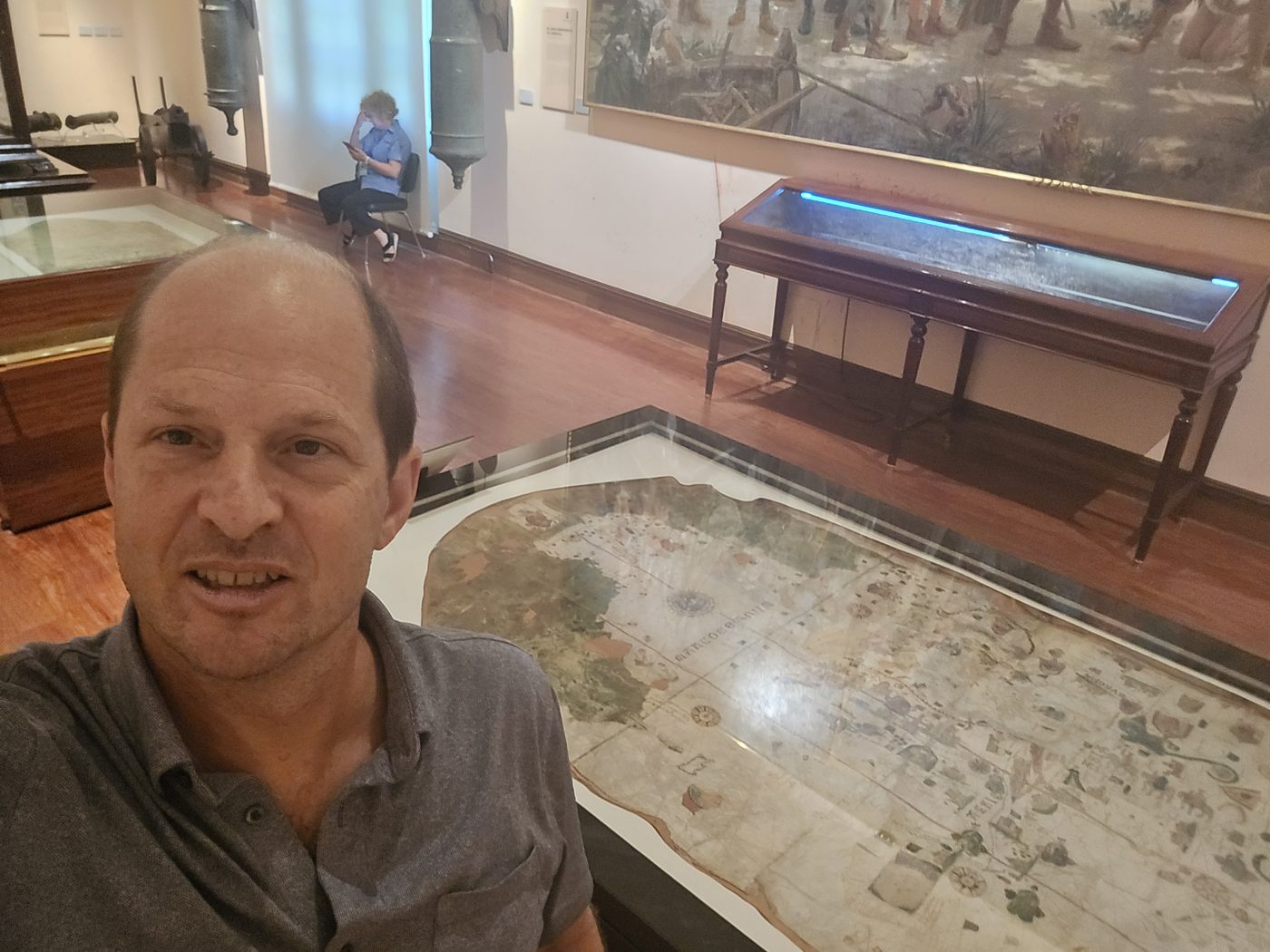
In July of 2026, I personally examined the original De la Cosa map at the Museo Naval in Madrid with a magnifying glass — something Pickering never had the opportunity to do.
One of the keystones of Pickering's conclusion was his claim that Guanahani was two islands, not one — based on his reading of online photographs of the De la Cosa map.
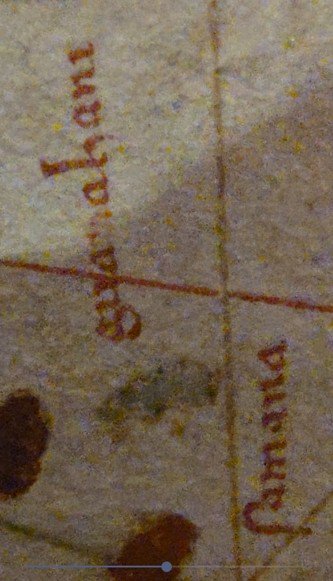
What Pickering reads as two islands separated by a channel, I — along with every cartographer and historian I have spoken with about it — believe is a single island with pigment loss in the oxhide parchment. The picture I took of the map through a magnifying glass shows a clear outline around one island.
It is possible, as Pickering hypothesized, that the darker spots in and near the outline of the Guanahani island are small islands. However, it is unlikely that De la Cosa would have depicted such incredible detail as a 100-meter-long or smaller island near Guanahani.
While examining the De la Cosa map in Madrid, I took pictures of other parts of the map where the same color pigment was used as was used by De la Cosa for Guanahani. These pictures show similar pigmentation fading and similar dots in the outline of the islands. Any of these other islands could, with the same pigmentation loss and dots in their outlines, look like multiple islands and/or have small islands around them. Click any image to enlarge.
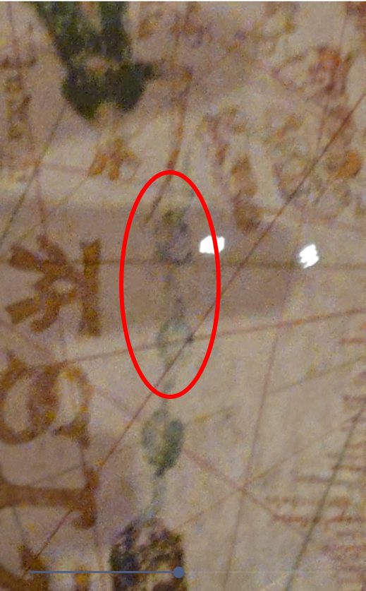
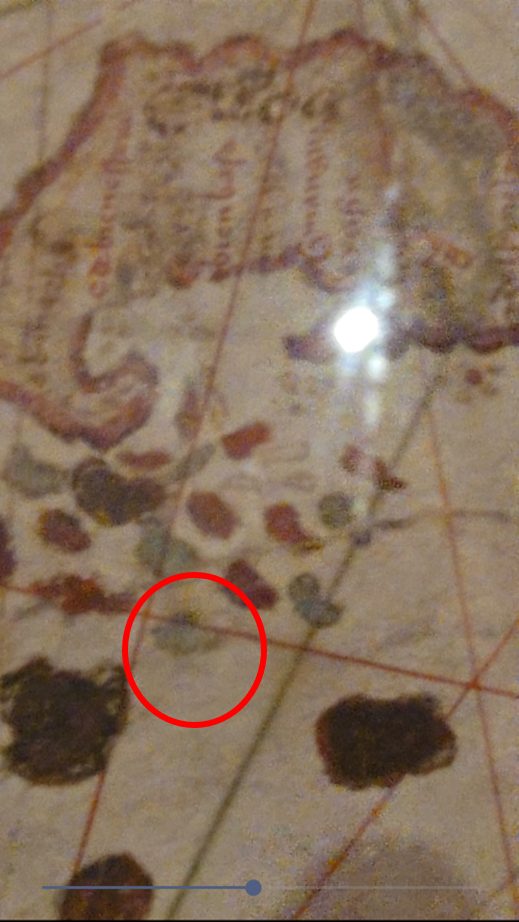
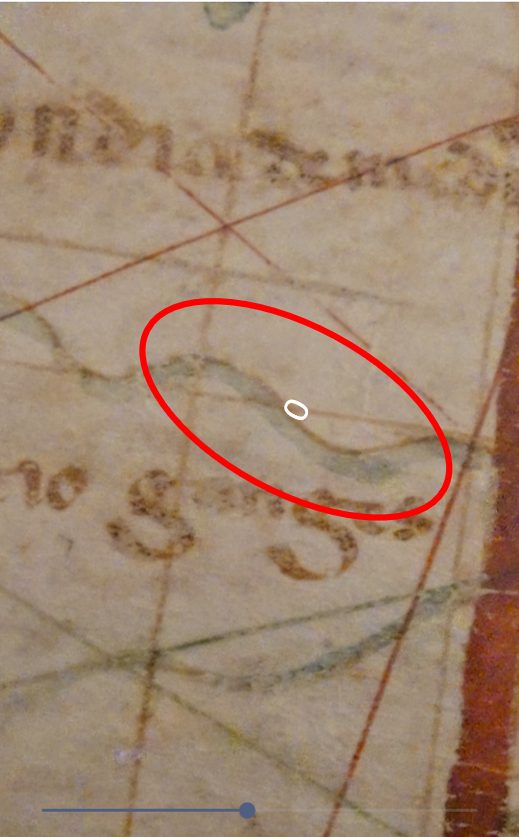
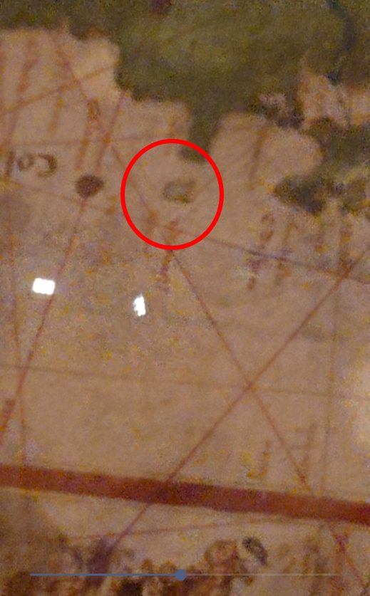
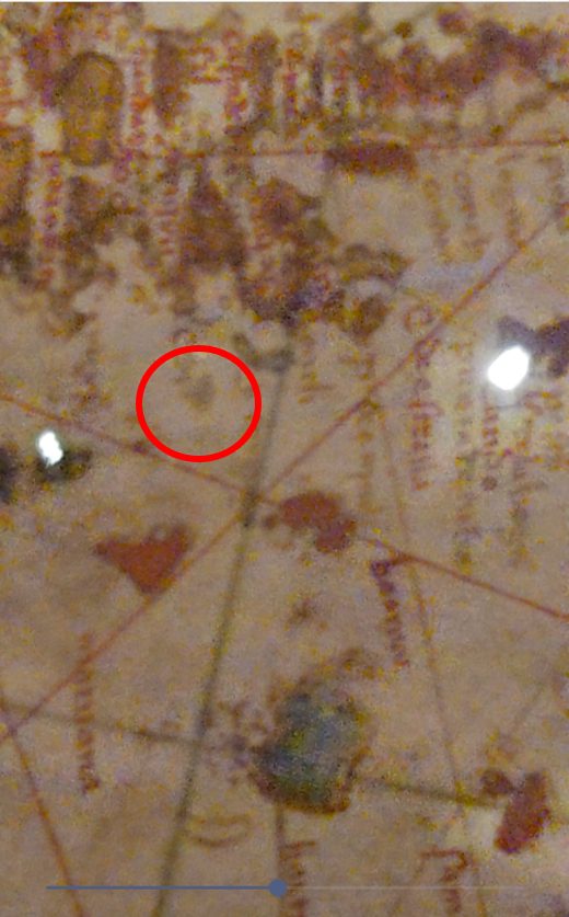
Confirming the one-island hypothesis is the description of the island in Columbus's Diario, which states that it had "a very large laguna in the middle." [1] It is difficult to reconcile a two-island landfall with this description.
Based on this photographic evidence from the De la Cosa map, I believe Pickering incorrectly scored Plana Cays too high — giving it points for being two islands and for having small islands — while Mayaguana received zero points on both counts, even though it also has small islets around it, simply because it is not two islands.
One last piece of analysis I have not seen made elsewhere is comparing the shape of Guanahani on the De la Cosa map to the potential landfall islands. Ignoring distortion from pigmentation loss, the De la Cosa map depicts an island with an oval shape, a more rounded northern coast, and a more jagged southern coast. Comparing island shapes to this form on the De la Cosa map is part of my scoring below.
Portuguese vs Italian Leagues
All distance-based analysis depends critically on the length of the league Columbus used. Virtually every researcher has assumed he used the Italian league (~2.67 nautical miles), because the consensus has historically been that Columbus was Genoese. For reasons that will become clear once Book Three: Uncharted Waters is published, [37] I strongly believe Columbus used the Portuguese Imperial League (~3.2 nautical miles). That assumption is not independently established in the literature — it is an artifact of the Genoese origin theory. When you question the origin, you must question the league. The importance of Portuguese vs Italian leagues is that it places Guanahani twenty percent further away from Island II.
Phonics Analysis
Columbus called the island where he made landfall San Salvador. So where did the name Guanahani come from on De la Cosa's map? I have not seen any explanation or analysis of this. My hypothesis, based on years of speaking, hearing, and mishearing words in Mayan languages in Guatemala, is that Guanahani is phonetically close to the name of the island used by the Taino inhabitants. I have researched and identified the Taino names of all the island candidates and compared them phonetically to Guanahani. Of note, we do not know the original Taino name for every island. Also, at least two islands are recorded with the name Guanahani, which is unlikely and points to inaccurate recording of names from an oral indigenous language. Therefore my analysis is binary — either a name is phonetically close to Guanahani or it is not. For example, Yabaque is not a close match; Maniwa is.
Population Estimates
Pickering did a rigorous analysis of population using better-documented populations of Pacific islands as a model for projecting native populations of Bahamian islands. However, it was based entirely on island size. He also used a model that totals roughly 140,000 Tainos across the islands, whereas I used 100,000. I have seen other estimates as low as 20,000, though this seems too low given the documentation by Peter Martyr that the Spanish took 40,000 slaves from the islands. I also used more factors, including the number and size of Taino archaeological sites (50% weight), fresh water availability (30% weight), and island size (20% weight).
Below is a table highlighting some of the differences, and the rationale behind them, between Pickering's population analysis and mine.
| Island | My Estimate | Pickering's Estimate | Why They Diverge |
|---|---|---|---|
| Andros | 4,022 (4.0%) |
52,837 (27.2%) |
Huge divergence. Pickering's model only factors in geographic area — Andros is 4x bigger than the next-largest island, so it wins by geometry alone. I discounted it substantially due to its thin, mostly-ceremonial archaeological record. |
| Middle Caicos | 5,974 (6.0%) |
3,542 (1.8%) |
Opposite divergence. My model rewards its significant archaeological site density (38+ sites, likely the regional chiefdom center); Pickering's formula only sees a modest 144 km² and has no way to know that. |
| San Salvador (Watling) | 4,883 (4.9%) |
2,738 (1.4%) |
Same pattern — its unusually well-documented archaeological site record was not accounted for by Pickering's size-only formula. |
| Great Inagua | 3,409 (3.4%) |
19,826 (10.2%) |
Pickering's model rewards its size; I discounted it for aridity (hypersaline Lake Windsor/Rosa dominates the interior). |
| Mayaguana | 3,162 (3.2%) |
5,814 (3.0%) |
Close, but Pickering's model places the population too high for it to fit Columbus's description. |
| Plana Cays | 1,428 (1.4%) |
557 (0.12%) |
Pickering overestimated Plana Cays' land area, which produced his published estimate of 864 persons. Using the correct GIS-measured size, his own formula gives 557 — and the archaeological record suggests the true figure is higher still. |
Pickering's own model, run raw across the Bahamas and Turks & Caicos, predicts approximately 194,000 people before any adjustment. After his own manual discount for late-settled northern islands, he arrives at roughly 140,000 for the Bahamas alone — which itself seems like a tacit acknowledgment that his size-based analysis had flaws. The geographic size he used for each island, listed on page 107 of his book, [3] also appears to rely on pre-GIS measurements: his figure for South Caicos is 233% larger than its actual size, while his figure for Exuma is 36% smaller than its actual size. [6] This matters directly for Plana Cays: he used an area of 16 km², divided 61%/39% between the two islands, to calculate his population estimate of 864. When the correct, GIS-measured island sizes are used instead, that estimate shrinks to 557. [6]
Why So Much Disagreement?
The real problem isn't a lack of information, but too much of it. For the majority of island candidates, all one has to do to champion a theory is cherry-pick the evidence that supports it and omit what undermines it. When looking at the totality of evidence consistently for all candidates, one can effectively rule out all but three islands.
The Eleven Island Candidates
Pickering evaluates each candidate against approximately fifty criteria drawn from the Diario and other primary sources, scored 0–3 (0 = does not fit; 3 = perfect fit). Total scores are out of 162. I present Pickering's scores and my own on a 0–100 scale.
The Virgin Islands lie approximately 1,000 miles southeast of the Bahamas, east of Puerto Rico. Any route placing Columbus's first landfall here would require him to have sailed past Hispaniola — an island roughly the size of Ireland — without recording it.
MethodologyThe theory relies solely on the transatlantic track, specifically a disputed reading of a September 13, 1492 Diario entry made in the middle of the Atlantic. No backward inter-island reconstruction from Cuba has ever been attempted, because none is possible.
Who Proposed It and WhyDr. Luis M. Coin Cuenca proposed the Virgin Islands as the landfall in 1989, based on his interpretation of Atlantic current patterns. [10] He has attracted no subsequent supporters.
Evidence in Its FavorA single ambiguous Diario entry from mid-Atlantic is the sole basis for this theory.
Evidence Against ItThe theory requires Columbus to have sailed past Hispaniola without observing or recording it, and to have crossed several hundred additional miles beyond what his log records. No inter-island route from the Virgin Islands to Cuba is consistent with the log.
Lignum Vitae Cay (also called Great Harbour Cay) is located in the Berry Islands at the extreme northern end of the Bahamian chain, approximately 500 miles northwest of where all serious theories place the landfall.
MethodologyThe theory relies on a claimed physical fit between Lignum Vitae Cay and Columbus's Island I descriptions. No viable transatlantic track or backward inter-island reconstruction supports this location.
Who Proposed It and WhyJohn H. Winslow, a professor at Florida Atlantic University, proposed this theory in 1989 after personally visiting Lignum Vitae Cay and Great Harbour Cay. [11] He has attracted no subsequent supporters. Sun-Sentinel, 1990.
Evidence in Its FavorThe physical description of the island — particularly the central lake and multicolored stones — has some superficial correspondence with Columbus's Island I descriptions. Winslow at least visited the island, which is more than most theorists did.
Evidence Against ItReaching Lignum Vitae Cay requires Columbus's ships to have passed through or near Treasure Cay or Harbour Island, neither of which appears in the log. The proposed route requires transiting the Middle Bight of Andros Island, a shallow tidal area approximately three feet deep. No island or distance descriptions in the Diario support a northern Bahamas landfall.
Cat Island is a long, narrow island in the central Bahamas, approximately 48 miles long and one to four miles wide, running roughly north-northwest to south-southeast. It was labeled "San Salvador" or "Guanahani" on 18th-century charts before anyone had seriously analyzed the Diario — the theory's origin is cartographic tradition, not navigational evidence.
MethodologyThe Cat Island theory predates systematic analysis of the Diario and is based primarily on historical cartographic tradition, not navigation reconstruction.
Who Proposed It and WhyMark Catesby identified Cat Island as Guanahani in his Natural History of Carolina (1731). [13] The theory gained its most influential support when Washington Irving asked U.S. Navy Commander Alexander Slidell Mackenzie to evaluate the two leading theories of the day. Mackenzie favored Cat; Irving published the analysis in 1828. [14] Alexander von Humboldt supported it in 1837. [15] The theory lost traction after the Diario was published in full in 1875–76.
Evidence in Its FavorHistorical cartographic tradition placed Guanahani at Cat Island on many 18th-century charts. The origin of this convention is itself unresolved. Also, its Taino name, Guanima, is phonetically similar enough to Guanahani that it passes my phonics criterion.
Evidence Against ItCat Island has no reef completely surrounding it — a clear Columbus criterion. There is no enclosed large harbor. The proposed Island II (Conception) is far too small: less than two leagues north-south and east-west against Columbus's five and ten leagues respectively. The proposed Islas de Arena are the non-existent "Mucara" islands.
Egg Island is a tiny landmass of approximately 0.2 square miles off the western tip of Eleuthera in the northern Bahamas, far from any transatlantic track placing the landfall in the central or southern Bahamas.
MethodologyThe theory relies on a transatlantic track requiring Columbus to have been a celestial navigator — something U.S. Navy Rear Admiral Bob McNitt's analysis of the log demonstrates he was not. The inter-island route requires crossing the Great Bahama Bank.
Who Proposed It and WhyArne B. Molander, a retired civil engineer, proposed Egg Island in 1981 and has been its sole serious advocate since. [16] His defense of the theory's many problems frequently invokes what Pickering calls the "All Purpose Indian Map Excuse" — when the log contradicts the theory, Molander asserts Columbus was misled by an inaccurate native map. But Columbus himself wrote that he could not obtain cartographic information from the natives until he had learned their language.
Evidence in Its FavorEgg and Royal Island together have a surrounding reef and a reasonably sized harbor at Royal Island.
Evidence Against ItThe proposed route from Island III to Island IV crosses approximately 90 miles of the extremely shallow Great Bahama Bank at speeds requiring Force 6 winds — conditions under which that passage would be impossible. James E. Kelley Jr. (1992) made a convincing and unrefuted argument from Columbus's own report of the canoes that visited on October 13: the minimum population of San Salvador (Guanahani) was between 634 and 1,115. [17] Egg Island is far too small to have supported that population. Pickering lists 28 unresolved problems.
Conception Island is a small, uninhabited island in the central Bahamas, southeast of Cat Island and northwest of Rum Cay. Its position within the central Bahamas gives it more geographic plausibility than the northern and southern outliers.
MethodologyThe theory uses both transatlantic track analysis and inter-island reconstruction, as well as archaeological and paleogeographic analysis of Bahamian shorelines as they existed in 1492.
Who Proposed It and WhyRupert Gould proposed Conception Island in 1943. [18] Geologist Steven Mitchell and archaeologist William Keegan later used paleogeographic reconstruction of 1492 shorelines to argue for Conception [19] — a methodological approach worth acknowledging even if unconvincing to most analysts.
Evidence in Its FavorConception Island has a surrounding reef and reasonable harbor. The island is flat and green. Archaeological evidence suggests Lucayan settlement. The paleogeographic reconstruction by Mitchell and Keegan is a valid methodological contribution. [19]
Evidence Against ItThe inter-island route from Conception requires Island II to have a north-south coast facing Island I — but no island facing Conception from the south matches this description. The proposed island chain does not map cleanly onto the log's distances and directions.
Watlings Island was officially renamed San Salvador Island by the Bahamian parliament in 1926, legally cementing its standing as the landfall. Most world maps still identify it as Columbus's first landfall — an authority that has outlasted the scholarly consensus that once supported it.
MethodologyThe quintessential transatlantic track theory. Samuel Eliot Morison spent five months in 1939–40 personally retracing Columbus's route under sail. [22] John W. McElroy's 1941 technical study of ship performance provided the underpinning Morison incorporated into his 1942 biography.
Who Proposed It and WhyJuan Bautista Muñoz first suggested Watlings in 1793. [20] A. B. Becher revived it in 1856; Lieutenant Joseph B. Murdock provided the most detailed 19th-century defense in 1884. [21] The theory's dominant 20th-century position rests almost entirely on Samuel Eliot Morison's Pulitzer Prize-winning Admiral of the Ocean Sea (1942). [22] Philip Richardson and Robert Goldsmith of the Woods Hole Oceanographic Institution reaffirmed Watlings in 1987 using Atlantic current modeling. [23]
Evidence in Its FavorWatlings Island has a large central lake — the best match among all candidates for Columbus's "very large laguna in the middle." [1] The transatlantic track reconstructions of McElroy and Richardson-Goldsmith both end near Watlings. Archaeological excavation at the Long Bay site confirmed Lucayan habitation consistent with Columbus's population descriptions. Morison's personal sailing experience gave his conclusions empirical grounding absent from purely theoretical analyses. Also, the Taino name — Waanhani, though I have also seen it recorded as Guanahani, one of two islands supposedly given that name — is phonetically close, or better, to Guanahani.
Evidence Against ItSupport for Watlings collapsed in the scholarly community after 1996 when Pickering resolved the leagues-versus-miles question. [5] Once established that the Bahamian descriptions are in leagues, the route unravels: Rum Cay's north-south coast measures less than two leagues against Columbus's five, and its east-west coast less than four leagues against Columbus's ten. The surrounding reef at Watlings does not completely encircle the island. The reef entrance is approximately 1,400 meters wide — not "very narrow." One of the biggest detractions for me personally is that it would have been impossible for Columbus to have seen a light from any nearby island hours before landfall — a requirement of the October 11 evidence. Pickering lists 28 unresolved problems.
East Caicos is the largest of the Turks and Caicos Islands, lying at the southern end of the Bahamian archipelago just north of the Windward Passage. It is approximately 18 miles long and was heavily settled by the Lucayan people.
MethodologyThe theory uses inter-island reconstruction, working forward from Caicos as Island I through Mayaguana, Acklins, and Great Inagua to Cuba.
Who Proposed It and WhyPieter Verhoog, a Dutch sea captain, proposed Caicos in 1947. [24] His theory gained support from Edwin and Marion Link in 1958 [25] and Robert Fuson in 1961. [26] Verhoog's confident declaration — "I have never found a single serious objection against Caicos" — suggests he had not scrutinized the inter-island track rigorously enough.
Evidence in Its FavorEast Caicos is large enough to match Columbus's "fairly large" description and has a lagoon and considerable Lucayan archaeological evidence. Its position in the southern Bahamas is consistent with transatlantic track analysis using Portuguese leagues. Oviedo's Historia general (1535) notes that Guanahani was adjacent to an island called "Caicos." Also, its Taino name was Guana, which is close to Guanahani, and even closer if combined with the Middle Caicos name, Aniana, to make Guananiana.
Evidence Against ItCaicos comprises five islands, not one. The pre-contact Lucayan population was almost certainly several times larger than the 500–1,100 range Columbus's descriptions imply. The Island II distance is severe: approximately 40 nautical miles from Caicos to Mayaguana — far outside Columbus's five to seven leagues even using Portuguese leagues. Pickering lists 19 unresolved problems.
Grand Turk is the easternmost island in the Lucayan archipelago, now the capital of the Turks and Caicos Islands. It is a small, low island surrounded by small sandy islets of exceptional whiteness.
MethodologyThe Grand Turk theory relies primarily on transatlantic track analysis combined with a selective reading of early historical sources. The inter-island reconstruction is its weakest element.
Who Proposed It and WhyMartín Fernández de Navarrete proposed Grand Turk in 1825. [27] The theory was periodically revived — by H. E. Sadler in 1980, Robert H. Power in 1983, [28] and Josiah Marvel in 2016. [29] Power acknowledged his theory's most serious problem: his proposed Island III requires Columbus to have mistaken open ocean for a coastline. [28]
Evidence in Its FavorGrand Turk is surrounded by small sandy islets of exceptional whiteness, matching Oviedo's 1535 description of the islands near Guanahani. The October 11 light fits well — potentially coming from another island to the east. Pickering gives Grand Turk a perfect 3 on the October 11 light criterion. Its Taino name, Amuana, is the weakest match of any island that still passes my phonetic criterion.
Evidence Against ItThe inter-island route requires Columbus to have sailed 58 nautical miles in six hours at ten knots — faster than his ships could sail. The theory requires him to have interpreted open ocean as a coastline for Island III. The Island I to Island IV distance is approximately five times what Columbus states. Pickering lists over fifteen unresolved problems.
Samana Cay is a small, uninhabited island lying north of Acklins Island in the central-southern Bahamas, approximately 60 miles east-southeast of Long Island. It is roughly oval with an east-west orientation, low-lying, and surrounded by reefs.
MethodologyBackward inter-island reconstruction from Cuba, placing Crooked-Acklins as Island II, Long Island as Island III, and Fortune Island as Island IV — the same route used by Plana Cays and Mayaguana.
Who Proposed It and WhyGustavus V. Fox, former Undersecretary of the U.S. Navy, first proposed Samana Cay in 1882. [30] Criticized by James B. Murdock in 1884 [21] — Fox had died in 1883 and could not respond — the theory lay dormant for a century. Joseph Judge revived it dramatically in National Geographic (November 1986). [31] Alejandro Perez subsequently found evidence in Las Casas's Historia de las Indias that refuted Murdock's objection.
Evidence in Its FavorSamana Cay is completely surrounded by a reef — one of Columbus's clearest Island I criteria. The shared route through Crooked-Acklins, Long Island, and Fortune Island is the strongest inter-island sequence in the debate. The De la Cosa map shows Guanahani with small islets, and Samana Cay has one distinct islet to the east and one to the south — a configuration that fits the map reasonably well. Numerous Lucayan archaeological sites have been identified on the island, consistent with the population range Columbus describes. Samana is one of two islands whose geographic form is similar to the depiction of Guanahani on the De la Cosa map.
Evidence Against ItSamana Cay has three unresolved problems. First, there is no obvious island to the east that could have produced the October 11 light. Second, the coast of Crooked-Acklins that faces Samana runs east-west, not north-south as Columbus describes for Island II. Third, Samana Cay has no central pond matching the "laguna muy grande." Samana Cay, at 30 miles from Island II, is too far — even using Portuguese leagues and a 15% margin of error — to have been 5 to 7 leagues away. Lastly, Samana is simply not close enough phonetically to Guanahani.
"It is impossible to explain the facts at our disposal in any other way. The solution to the mystery is Samana Cay." [31]Joseph Judge, Senior Editor, National Geographic
The Plana Cays consist of two islands — North Plana and South Plana — in the southeastern Bahamas, east of Acklins Island and west of Mayaguana. This two-island geography is both the theory's central strength in Pickering's analysis and, in my view, its central weakness.
MethodologyBackward inter-island reconstruction from Cuba, following the same Crooked-Acklins to Long Island to Fortune Island route as Samana Cay and Mayaguana. Pickering additionally applies transatlantic track analysis using updated 2004 geomagnetic field models.
Who Proposed It and WhyThe Plana Cays theory was first proposed by Ramón Julio Didiez Burgos in Guanahaní y Mayaguain (1974). [32] Pickering revived it in a 1994 article in the journal DIO and has been its most vigorous proponent since. [33] At a 1992 U.S. Naval Institute debate, moderator William F. Buckley awarded a TKO to the Plana theory after Pickering demonstrated it was the only candidate whose Island II had a north-south coast facing Island I.
Evidence in Its FavorThe critical directional clue — the north-south coast of Island II (Crooked-Acklins) faces Island I — is satisfied by Plana (and Mayaguana). A surrounding reef is present. The De la Cosa map potentially shows Guanahani as two islands, which matches Plana's two-island geography. The 2004 geomagnetic track analysis is consistent with a central Bahamas landfall. The October 11 light fits well: it would have come from Mayaguana, directly east of Plana. Its modeled population is roughly in line with Columbus's description.
Evidence Against ItPlana Cays consists of two islands. Columbus never says Guanahani is two islands, and his description — "a very large laguna in the middle" [1] — describes a single unified landmass. As Joseph Judge wrote to Pickering: "If the Plana Cays were one island... it would absolutely be the landfall." (Worth noting: this was based on Italian leagues, which I dispute.) But it is not one island. The ponds at Plana are not in the middle of the island. There is no peninsula with a narrow neck. Acklins Island is marginally visible from the Plana anchorage — Columbus does not mention other visible islands until after leaving Island I. Additionally, it is unlikely the Lucayan population of Plana was sufficient to correspond to the number of people and canoes Columbus describes.
On the De la Cosa map: as described above, I examined the original at the Museo Naval in Madrid in July 2026. What Pickering reads as two islands separated by a channel appears to me to be a single island with pigment loss — a pattern I photographed repeated elsewhere on the same map, in places with no bearing on the landfall question. The Diario's own language supports the single-island reading. I do not accept this criterion as evidence for Plana.
On leagues: Pickering assumes the Italian league (~2.67 nautical miles). I believe Columbus used the Portuguese Imperial League (~3.2 nautical miles). Using Italian leagues, Guanahani was 13.3 to 16 modern miles from Island II — a range that only Plana Cays (about 15 miles from Crooked Island) fits. Using Portuguese leagues, that range extends to 18.7 to 22 modern miles, which brings Mayaguana (about 25 miles from Crooked Island) within Pickering's own ±15% margin of error as well. Under Italian leagues, only Plana fits; under Portuguese leagues, both islands do.
Lastly, the Taino name, Amawayo, is not phonetically close to Guanahani.
"If the Plana Cays were one island... it would absolutely be the landfall."Joseph Judge, former National Geographic Senior Editor, in a letter to Keith Pickering, August 10, 1992
While other factors such as Portuguese leagues and phonetics reduce the certainty of Judge's statement, two islands are still two islands.
Mayaguana is the easternmost island in the Bahamian archipelago proper, lying west of the Caicos Islands and east of the Plana Cays. At approximately 24 miles long and 6 miles wide, it is the largest island in the southeastern Bahamian cluster. Mayaguana is a single, unified island with a surrounding reef, a large bay (Abraham's Bay) on its southern coast enclosed by a reef line, and small islets on its eastern side. The island has no mountains, is flat, and is covered in green vegetation — matching Columbus's description precisely.
MethodologyI followed Pickering's backward inter-island reconstruction methodology. Starting from Cuba, working backward through the Ragged Islands, Island IV (Fortune Island), Island III (Long Island), and Island II (Crooked-Acklins), the route leads to the southeastern Bahamian cluster. Within that cluster, I depart from Pickering's conclusion for the reasons below.
Who Proposed It and WhyMayaguana was first proposed by Francisco Adolfo de Varnhagen in 1864 in La verdadera Guanahani de Colón. [34] Varnhagen was a Brazilian historian and diplomat who conducted serious primary source analysis — his identification of Acklins-Crooked as Island II and Fortune Island as Island IV were methodological innovations that Pickering later incorporated into his own Plana Cays theory. [34] The Marquis de Belloy supported Varnhagen in 1877. [35] The theory has had few serious advocates since.
Evidence in Its FavorMayaguana is a single island, consistent with Columbus's first-person description of Guanahani as a unified landmass with "a very large laguna in the middle." The two-island reading that favors Plana on the De la Cosa map is, in my view, an artifact of pigment loss rather than original cartography.
The name correspondence is striking and has been almost entirely ignored in the literature: Mayaguana is more phonetically similar to Guanahani than any other original Taíno island name in the Bahamas. The inversion of syllables — Guanahani / Mayaguana — is a recognized pattern in oral transmission of place names across language boundaries. I am surprised this has not been given more weight.
Mayaguana has small islets on its eastern side as well as a reef line along the southern boundary of Abraham's Bay — a single large island with associated islets, consistent with the De la Cosa map. The De la Cosa map equally supports Samana and Mayaguana on the islet criterion.
The distance from Mayaguana to Crooked Island is approximately 25 modern miles. Columbus describes the journey as "farther than five leagues, closer to seven," delayed by contrary tide and not completed until noon. [1] Plana Cays is approximately 15 miles from Crooked Island; Mayaguana approximately 25. Both fall within Pickering's ±15% margin when Portuguese leagues are used — but the qualitative feel of the passage (tidal delay, noon arrival) fits a 25-mile crossing more naturally than a 15-mile one.
Pickering himself acknowledges that Mayaguana has "by far the best fortifiable peninsula at Island I" of any candidate. [36] Abraham's Bay provides a large harbor between the reef and the island with a narrow entrance — matching Columbus's description closely. If Mayaguana is Island I, the October 11 light could have come from the Turks and Caicos, such as Providenciales. Plana Cay, which consists of multiple islands, is within five Portuguese leagues of Mayaguana — addressing Pickering's concern about visible islands after departure from Island I.
The historical record attributes a larger pre-contact population to Mayaguana than the 500–1,100 range Columbus's descriptions imply. However, archaeological population estimates carry significant uncertainty, and Columbus likely did not see the entire population. Some researchers suggest a native population of approximately 3,000 would be necessary to produce the visible signs Columbus observed of 500–1,100. My own population modeling estimates a population of 3,162 on Mayaguana in 1492.
Lastly, Mayaguana is phonetically close to Guanahani and, along with Samana Cay, has the closest geographic shape to the island of Guanahani on the De la Cosa map.
Evidence Against ItPickering raises several legitimate concerns. The distance from Mayaguana's likely west coast anchorage to the fortifiable peninsula on the east is approximately 25 nautical miles, making a round-trip boat journey in less than a day unlikely under normal conditions. However, Mayaguana is large, and a mariner would naturally explore it by boat rather than on foot — which actually supports the island's larger size.
The Island IV distance problem — Fortune Island is roughly twenty leagues from Mayaguana while Columbus states Island IV was eight leagues from Island I — is the same problem that affects Plana Cays and Samana Cay, and may reflect a navigational estimate rather than a precise measurement.
Sources by Island
General Sources
[1] Dunn, Oliver, and James E. Kelley, Jr. (1989). The Diario of Christopher Columbus's First Voyage to America, 1492–1493. University of Oklahoma Press.
[2] Pickering, Keith A. (1997, rev. 2010). The Columbus Landfall Homepage. columbuslandfall.com
[3] Pickering, Keith A. (2017). The Lost Island of Columbus. Sunbury Press, Inc. ISBN 978-1-62006-713-0. Island size data (p. 107) used throughout the population analysis above. amazon.com
[4] Pickering, Keith A. (1994). "Columbus' Plana Cays Landfall." DIO, Vol. 4 (1), pp. 15–32.
[5] Pickering, Keith A. (1995). "Leagues and Miles in the Log of Columbus: The Final Verdict." Lecture, Society for the History of Discoveries. columbuslandfall.com
[6] World Islands (world-islands.net). GIS-derived island area, coastline, and elevation data for the Bahamas and Turks & Caicos, used to correct Pickering's pre-GIS island size figures in the population analysis above. world-islands.net
[7] Bedini, S.A., ed. (1992). The Christopher Columbus Encyclopedia. Simon & Schuster. [Landfall Controversy, pp. 401–403]
[8] Wikipedia contributors. "Guanahani." Wikipedia
[9] Laufer, Joseph M. (1990). "A List of Proposed Landfall Islands over Time." Discovery 500, Spring 1990.
Virgin Islands
[10] Coin Cuenca, Luis M. (1989). Reported by Keith Pickering. columbuslandfall.com
Lignum Vitae Cay
[11] Winslow, John H. (1988). "Landfall of Columbus at Great Harbor Cay." Nassau Guardian, 7 November.
[12] Sun-Sentinel (1990). "Unsettling Idea: FAU Professor Challenges Columbus Landfall."
Cat Island
[13] Catesby, Mark (1731). The Natural History of Carolina.
[14] Irving, Washington (1828). A History of the Life and Voyages of Christopher Columbus, vol. IV. London: Murray.
[15] Humboldt, Alexander von (1837). Examen critique. Paris: Gide.
Egg Island
[16] Molander, Arne (1981). "A New Approach to the Columbus Landfall." Terrae Incognitae, vol. 15.
[17] Kelley, James E., Jr. (1992). Population analysis from Columbus's canoe count reports.
Conception Island
[18] Gould, Rupert (1943). Conception Island landfall theory.
[19] Keegan, W.F., and Mitchell, S. (1987). "The Coastline of the Bahama Islands, 1492." American Archeology, vol. 6, no. 2.
Watlings Island / San Salvador
[20] Muñoz, Juan Bautista (1793). Historia del Nuevo Mundo. Madrid: Ibarra.
[21] Murdock, Joseph Ballard (1884). "The Cruise of Columbus in the Bahamas." Proceedings of the U.S. Naval Institute, vol. 10.
[22] Morison, Samuel Eliot (1942). Admiral of the Ocean Sea. Boston: Little, Brown & Co.
[23] Goldsmith, R.A., and Richardson, P.L. (1992). Numerical Simulations of Columbus' Atlantic Crossings. Woods Hole Oceanographic Institution.
East Caicos
[24] Verhoog, Pieter (1947). "Columbus Landed on Caicos." Proceedings of the U.S. Naval Institute, vol. 80.
[25] Link, E.A., and Link, M.G. (1958). A New Theory on Columbus's Voyage through the Bahamas. Smithsonian Institution.
[26] Fuson, Robert (1961). "Caicos: Site of Columbus's Landfall." Professional Geographer, vol. 13, no. 2.
Grand Turk
[27] Navarrete, M.F. de (1825–37). Colección de los viages y descubrimientos. Madrid: Imprensa Real.
[28] Power, Robert H. (1983). "Discovery of Columbus's Island Passage to Cuba." Terrae Incognitae, vol. 15.
[29] Marvel, Josiah (2016). BBC World Latin America.
Samana Cay
[30] Fox, Gustavus V. (1882). "An Attempt to Solve the Problem of the First Landing Place of Columbus." U.S. Coast and Geodetic Survey, Appendix No. 18.
[31] Judge, Joseph (1986). "Our Search for the True Columbus Landfall." National Geographic, vol. 170, no. 5 (November).
Plana Cays
[32] Didiez Burgos, Ramón Julio (1974). Guanahaní y Mayaguain.
[33] Pickering, Keith A. (1994). "Columbus' Plana Cays Landfall." DIO, Vol. 4 (1). columbuslandfall.com
Mayaguana
[34] Varnhagen, Francisco Adolfo de (1864). La verdadera Guanahani de Colón. Santiago: Imprenta nacional.
[35] Belloy, Marquis de (1877). Christopher Columbus and the Discovery of the New World. [Supports Varnhagen, p. 96]
[36] Pickering, Keith A. "The Mayaguana Theory." columbuslandfall.com
[37] Balch, Graham (forthcoming). Book Three: Uncharted Waters. AMERICA Series.